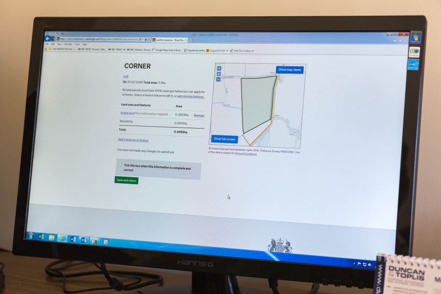
A new update on Gatekeeper means users are now able to import digital RPA field boundaries into the software for the first time. Charlotte Cunningham reports.
Gatekeeper has claimed to become the first farm management information system to provide a free and seamless integration with Rural Payments Agency digital boundaries.
According to Gatekeeper, these boundaries can be quickly and easily imported into the software, allowing users to quickly match their fields in Gatekeeper with their registered field boundaries.
This functionality is available to all users of the Gatekeeper Mapping module, and makes it much easier for users to create general farm management maps and better support precision farming activities, says the firm.
Unlocking value
Sarah Alexander, arable commercial product manager, said: “Our customers have been asking us to help them gain access to their digital RPA field boundaries for many years but until now they simply haven’t been available. We’ve worked hard to help make this happen and are delighted to be able to bring this added value to our Gatekeeper users.
“One of the biggest pain points for any farming business wishing to map their farm is accurately creating their field boundaries. This integration really unlocks value for our users and makes mapping their farm easier and more accessible than ever before.
“We’re always looking at ways that we can help our customers work more effectively and efficiently. The introduction of RPA boundary integration is a great example of that.”