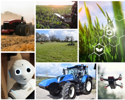
Managing the vast amount of data your farm produces could give you valued insight into how to boost its productivity, but just how do you do it? CPM reviews the leading four data-management solutions.
It’s a very easy tool to use and can be calibrated to the expectations of a crop.
By Charlotte Cunningham
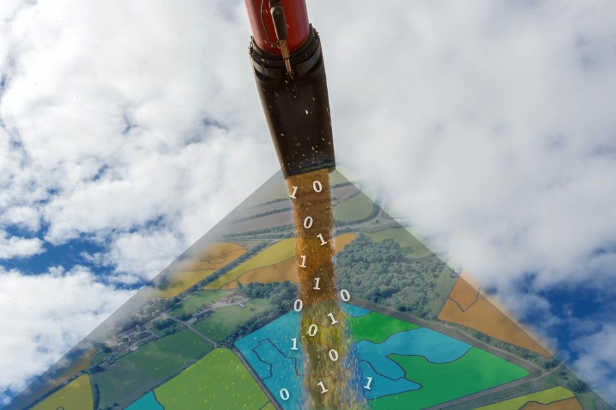
Few would dispute that agriculture is in the midst of a technological revolution, driven by data. As the need for greater efficiency has increased, there’s been a surge in the ability to collect critical farm data. Whether that prospect fills you with excitement or dread, there’s little doubting the potential to use it to drive agronomic and other business decisions.
While arable farmers have been collecting data for years – whether on crumpled notebooks in tractor cabs or stored in one of many files in a farm office – today this information needs to be instant, accessible and accurate, and that’s led to the birth of digital agronomy.
This new concept has transformed the way in which data is collected and utilised, and with proven effectiveness many firms are cashing in with their own version – each promising different functionality to farmers. So what options are there and how can they be used?
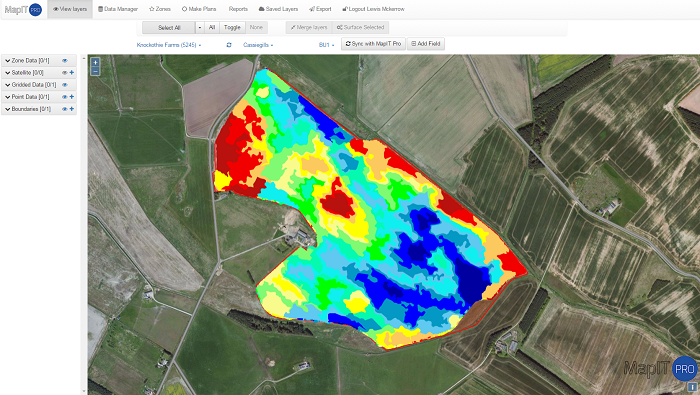
The MapIT Pro option focuses on precision farming, manages any level of data and can also be synchronised with machinery.
Agrovista – Axis
Officially launched at the 2015 Cereals Event, Axis is a web-based technical information exchange system that allows agronomy and precision farming data to be uploaded and shared in real time.
For use by both farmers and agronomists, the platform offers free access to Agrovista account information, as well as variety, fertiliser, disease, grain market and regulatory data. There are also four different paid-for modules offering a more in-depth management platform, explains Lewis McKerrow, head of precision technology at Agrovista.
“Subscription modules give users access to a whole range of other features such as gross margins and precision mapping – meaning users can manage any level of data from soil to drone maps.”
Subscription modules include Axis Field pro which is useful for record keeping – covering elements like cropping, inputs and costs – and allows users to build up gross margins for the farm. The Axis MapIT Pro option focuses on precision farming and uses a Google-based mapping system to manage any level of data – including soil and drone maps – and can also be synchronised with machinery.
Setting up Axis is fairly straightforward for existing customers, as an archive of farm data is usually already in place, says Lewis. “For new customers, it’s a case of filling in a requirement form and manually inputting field data such as names and boundaries.” Data can also be directly imported from Gatekeeper, he adds.
While the software doesn’t boast advanced analysis tools, it does provide farmers with all the necessary data to make management decisions. “The usefulness of the software is dependent on how much data is put in,” he explains. “Basing decision on one year’s worth of yield data can be unreliable without any other background knowledge, so the more different types of information you put in, the better the output will be.”
Farmers own all the data themselves – it’s stored in the cloud and can be manually synchronised across several devices. “Axis is completely web-based so it can be used on the computer, a mobile or a tablet using an app.”
Agrovista faced difficulty during the design process when trying to get advanced mapping tools to function on a web-based system. This led to a partnership with Muddy Boots software to help progress the system. With Muddy Boots as a technical partner, the Greenlight Grower Management (GLGM) system is an integral part of Axis’ design. “Growers can add cropping into GLGM which immediately synchronises with the agronomist to improve efficient management and cuts down on the duplication of data,” says Lewis.
So how much does it cost? “The basic level of service is free and then the cost increases depending on how much functionality a farmer requires. The lowest cost subscription starts at £120/year – offering growers the addition of a field-recording system – and goes up to £700, best suited to farmers with over 5000ha and looking for a full crop-recording system which offers information on machinery and sprayer operations and grass and nutrient margins.”
And what’s next for Axis? “Version two of the software is due to be launched later this year which will be a lot more data driven rather than information driven,” says Lewis. “The use of drones is becoming a lot more popular, so it’ll also integrate drone imagery to nutrient management.”
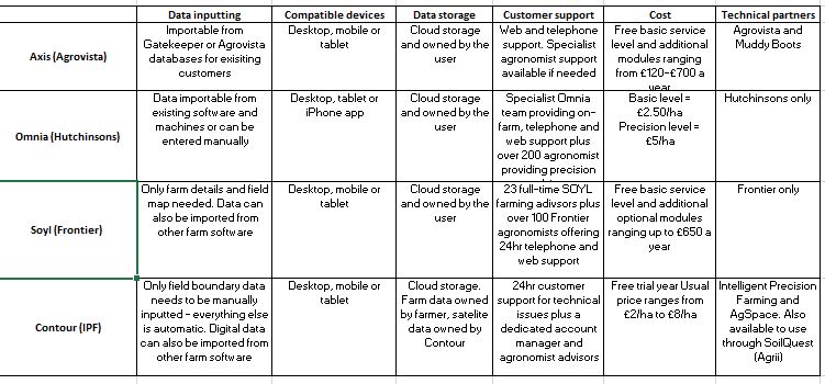
Frontier – Soyl
MySoyl – delivered by Soyl, a division of Frontier Agriculture – is a data-driven tool within Frontier’s myFarm online platform designed to aid collaboration between growers and agronomists by collating and analysing precision data in one place.
The system uses satellite imagery, sensors and drone imagery but as with all these types of software, it’s the system’s ability to aid analysis and identify trends that offers the most potential, explains Simon Parrington, managing director at Soyl.
“MySoyl provides users with information on the profitability of an individual field, taking into account different layers of data. This includes yield, weather, nutrients, soil type and drainage as well as drawing on satellite imagery Normalised Difference Vegetation Index (NDVI) and Leaf Area Index information to look back on up to five years of data.”
The system also boasts a free scouting app for use on tablets and smartphones, meaning data can be collected out in the field and synchronised with other devices such as laptops.
Both using the system and setting it up is relatively simple, and the farm details and map are all that are needed to get the system going. Existing data from other farm software can also be imported, he adds.
As well as the basic level information, there are several modules that users can subscribe to. “The crop planning module generates cropping plans and selects suitable varieties for the farm while the nutrient-management module considers phosphorous, potash and lime use and advises when and where to target according to farm budgets.”
Other modules include mapping, data analysis and variable rate seed tools, as well as the option to create custom applications, says Simon. Data is fully exportable to all the main manufacturers’ machines, or you can wirelessly transfer the data to an iPad app which controls kit such as sprayers.
Pricing varies depending on the level of service needed. “The basic level is free, and the maximum is £650/pa. The most common level sold is £350/year which does everything except advanced application mapping.”
While precision data is a hot topic right now, there really are some tangible benefits to farmers, explains Simon. “It’s really important to make data very simple and easy to use over multiple devices. Even just from a yield perspective, being more precise can lead to improvements of up to 12%.”
Hutchinsons – Omnia
Developed by Hutchinsons, Omnia is a cloud-based software system designed for nutrient management and precision farming.
Unlike other systems, it offers users advice based on the use of layered field data. This layering technique means that all management aspects which relate to a variable input decision can be superimposed on to each other, explains Oliver Wood, precision technology manager at Hutchinsons.
“Farming has always had a layered approach – it’s not just a case of looking at soil type – and Omnia reflects this. For example, when determining variable seed rates, the influence of soil type, seedbed condition, weed pressure and slugs can all be considered together.”
Omnia is available in two different service levels – Omnia and Omnia Precision. The basic level includes a simple mapping system and the functionality to create crop nutrition plans and compliance reports.
Omnia Precision goes one step beyond this, adding in the ability to create different map layers, such as weed and soils. Using built-in algorithms, multi-dimensional analysis creates variable rate application plans which can be exported to machinery. Yield mapping is a particularly useful feature for farmers looking to analyse long term performance of a field, he adds.
“It’s a very easy tool to use and can be calibrated to the expectations of a crop. With the field-performance map, it highlights the good and bad areas in a field and offers answers to why the poorer areas may underperforming.”
As well as physical analysis, the platform allows growers to access and understand their cost of production.
When it comes to set-up ease, it’s largely dependent on how much farm data is already in a digital format and it can be imported from other software, says Oliver. “Farming software is inherently difficult to use, so we’ve tried to reflect ease of use in the design – people don’t want to spend a long time setting software up.”
Omnia can be accessed on a desktop and in the field on a tablet and is synchronised between devices to allow real time updates to be shared between farmers and agronomists. There’s also an iPhone app, Field Scout, to allow users to access mapping on their phone, explains Oliver.
So how much does Omnia cost? “The non-precision level (Omnia) is £2.50/ha, whereas the precision level (Omnia Precision) is likely to cost a farm £5/ha,” he says. “Pricing is based on a tiered structure, meaning the price/ha goes down for bigger farms.”
This flexibility means farmers can tailor the software to the needs of the farm. “Every farm is different, which is why we don’t use a rigid price structure. To be the most profitable, businesses need to have a plan of what they want to achieve and what their limitations are.”
Intelligent Precision Farming and Agrii SoilQuest – Contour
Precision agriculture may be revolutionising farming practices, but there’s also an argument that it’s become over-complicated. With this in mind, AgSpace has developed a platform – delivered by via precision farming companies Intelligent Precision Farming and SoilQuest – to bring everything back to basics, named Contour.
“There was a noticeable demand for a tool that could be used for daily decision making,” explains Vince Gillingham, founder at AgSpace and IPF. “We’ve worked with farmers for a long time using a platform called Toolbox. While it provided farmers with every bit of data they needed, it was very tech-heavy.”
Contour is the replacement for the older Toolbox software and provides users with information about soil and crop condition, water availability and field accessibility. It’s updated every 24 hours using satellite data and hyper local weather via a digital weather station on farm – local weather data is automatically corrected for your farm.
A neat feature is the use of NDVI to monitor crop performance. “This works by scanning a farm every day using a satellite. Images are then automatically produced and uploaded to the platform,” explains Vince. “This means growers can make decisions daily, based on the most up-to-date information. Performance can then be compared with soil analysis to assess how a crop is responding.”
Another impressive feature is the use of Synthetic Aperture Radar (SAR) technology to predict crop growth information. This allows fields to be scanned by satellite even on cloudy days. “Using a radar, a signal is bounced off the surface of a crop to look at the structure of the plant. Using this data in combination with weather data – such as sunlight levels, rain and temperature – it can predict the leaf area, biomass production and growth stage of a crop.”
The precision level of this has been proven in trials over the past three years, where the system has predicted wheat yields at GS37 within 10% of the actual harvest yield.
When crop walking, specific field information can be recorded on a phone or tablet which then will automatically share the data to all devices as soon as it receives a data signal. “Data can also be exported to most machines.”
Contour is an extremely easy platform to set up, says Vince, with only field boundaries needed to launch the platform and the rest of the data uploaded automatically. For the more in-depth analysis, cropping data and drilling date also has to be inputted annually, while data that’s already digitalised can be imported from other software, he adds.
The entry level to Contour provides the hyper local weather data and crop-monitoring tools providing NDVI, leaf area and biomass. Although the system is cloud-based, the data can be downloaded to a tablet or phone so that crop scouting doesn’t rely on a mobile phone signal.
After a free trial period, this basic service level begins at £2/ha. There are several additional packages, each boasting different levels of functionality – ranging from £4-9/ha.
“Contour is for all farmers, not just for hardcore precision farming converts. It’s for daily decision making and this provides farmers with very valuable data that’s updated every day,” notes Vince.