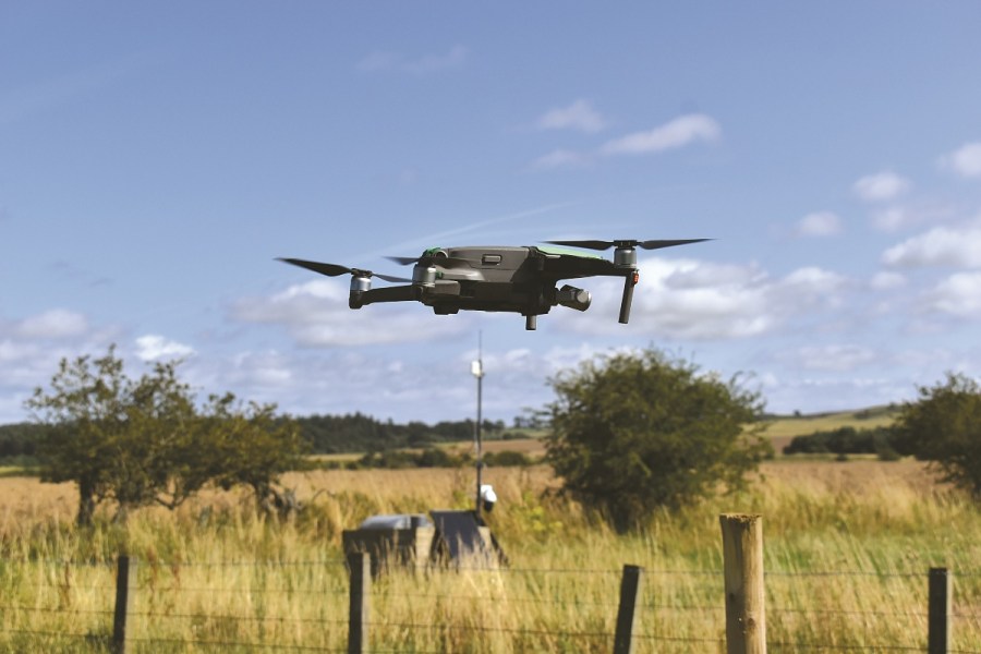
The innovation pioneered by Drone Ag is pushing the capabilities of drone technology for farmers further than ever before. CPM travelled to Northumberland to see its latest developments in action.
By operating in this way, we can offer farmers and agronomists a service that will scout fields up to 20 times faster than on foot.
By Charlotte Cunningham
The winding roads that sweep and curl through Alnwick, Northumberland are alive with the sound of combines humming away munching through this year’s crops, as the sun shines down gently kissing the land surrounding the Harehope estate after what’s been a fairly lacklustre summer.
The estate is home to third-generation farmer, Jack Wrangham – otherwise known as the founder of Drone Ag.
It’s fair to say that as the capability and feasibility of incorporating drone technology on farm has increased, Drone Ag has been segment leaders with its software – Skippy Scout – which is claimed to be able to take any ‘off-the-shelf’ drone and turn it into an automated data collection tool to aid monitoring and decision making by both farmers and agronomists. “This works alongside an image analysis system so once pictures have been captured by the drone, the AI analyses them and provides statistics like crop cover,” explains Jack. “This information is condensed into a report and available to the grower within a few minDutes of landing.”
Skippy was only launched officially last March, but now the firm are launching version 2.6 which is set to increase push data-capturing and analysis even further, he says.
“We’re trying to shape the software to meet the exact requirements of growers, and something we had a lot of requests for was a plant counting functionality. This was seen as particularly useful for crops like cereals where, at the moment, agronomists have to go and physically count emerging crops across fields to assess whether emergence is on par with seed rates etc.
“Therefore, we’ve been working hard on building a plant counting module, which is now available.”
The system enables the drone to drop down to each point in the field and give you an accurate calculation of plants/m2.
“Within minutes, growers will be able to attain whole field data – far quicker than would ever be possible by physically walking the crops,” notes Jack.
“Because we’re able to get so close to the crop, we’re getting really high-resolution images so growers or agronomists will be able to see signs of emergence as soon as a week post drilling – this is really advantageous over something like satellite imagery as we’re able to delve into much higher detail earlier on in the plant’s life cycle.”
The plant counting module will be a free update to existing users and won’t require any manual updating of applications, he adds. “This will simply show as an additional stat on the flight report and will work on up to 15% crop cover on broadacre crops.”
Another new development which the firm aim to launch over the next few months is an update to the flight system, explains Jack. “Essentially the system we launched last year was the first version of ‘Flight’ and we estimated that to be about five times quicker than walking a field. The current system, Flight 2.0 is a lot smoother which made it a lot quicker too – about 10 times faster than walking.
“The challenge with the current system is that if, for example, there’s a power line across a field, the drone will fly above that height for the whole duration of the flight. However, this isn’t very efficient.
“So, with 3.0, we’ve designed a system which models the whole field in 3D space – taking into account power lines, trees, hills, etc – and it builds a flight path which flies through that space in the most efficient way possible. It will hug the terrain and simply fly higher when it needs to.”
In terms of the impact this will have, Jack estimates that lifespan will be two times better with the new system, much more efficient and quicker. “A journey which would have previously taken five minutes will now take just over two.”
So far, a lot of drone usage has been focused on pin-point images and something that’s been missing is a whole field overview, says Jack. “We import satellite data now to give us that, but we always knew we wanted to build a way for a drone to collect a whole field overview very quickly.
“Drone mapping has been available for a very long time – there’s plenty of software out there which will map a whole field for you – but the drone has to fly forwards and backwards taking lots of images and then stitch them together. So it’s not particularly efficient either and involves a very intensive data analysis process.
“Satellite data can be generated a lot quicker, but it’s generally a lot lower resolution and can be impeded by cloud cover.”
And its these challenges which have led the firm to where they are today, he explains. “Over the past couple of months, we’ve built ‘Scout Spheres’ and essentially what this does is sends the drone to the centre of the field – flying at about 100m above ground – and enables the drone to take photos through a sphere in a similar way to taking a panoramic photo on your mobile.
“The image can be generated within 30 seconds and viewable from anywhere in the world within a few minutes. We’ve also overlayed this with scouting points – so it’s not just a way to get an overview, it’s a way of accessing whole field data very quickly.”
Though not commercially available – nor yet feasible from a legislation point of view – arguably the most exciting development under the Drone Ag umbrella is the new base station technology, Skippy Nest.
Sat in the corner of a field in a potato box, the technology doesn’t look all that whizzy, but when you get a little closer and see it in action, the capabilities are really rather impressive. “We’ve built the technology in a potato box largely as we knew that this is something farmers can transport around farm very easily,” explains Jack.
So how does it work?
The ethos behind Skippy Nest is that the base station technology will allow a drone to be flown from anywhere in the world – without the need for an operator in the field.
Obviously, this has legal implications (see box) as current rules don’t allow unmanned operating.
However, what is possible is that a member of the Drone Ag team, for example, could fly the user’s drone remotely – so long as they are able to intercept the flight if necessary – which removes any barriers where lack of experience with drones stops growers using them, points out Jack.
“By operating in this way, we can offer farmers and agronomists a service that will scout fields up to 20 times faster than on foot and email them PDF reports of GAI, weed and pest data in real time.”
As the demo flight leaves the nest, the on-screen display confirms it can deliver this data collection in real-time, with the drone’s eye just a second in front of the feed shown on screen.
The base station is solar powered, linked to a battery to charge the drone. The drone itself is encapsulated in a hardened steel canopy which has proven itself to be completely weather-proof over a challenging winter, laughs Jack. It’s also airconditioned to ensure nothing freezes or overheats through the season, too.
The thinking behind the innovation is that the base stations can be placed at multiple points around the farm and flown automatically to collect data. “The ultimate goal is for the farmer or user not even needing to decide when to scout a crop – the drone will do that itself.
“We can use information like cropping type, the time of year, the weather and any particular disease or pest risk periods and feed it into the software, then the technology will be able to decide for itself when it should go and scout a crop – sending the report directly to the farmer without the need for intervention.
“The technology is there to be able to do this, but it’s now a case of working with industry partners to bring in those various data sources and deciding what’s actually relevant and useful for growers.”
The prototype is very much the first generation, with other tweaks and modifications required before it’s ready to be offered commercially so watch this space for more information…
Legalities debunked
The rules and regulations on drone usage changed at the end of last year to bring UK rules in line with EU guidance post-Brexit. So what are the legalities of owning and flying a drone on farm today?
The Civil Aviation Authority set out the regulations and the most basic of the rules ensures any drone weighing between 250g and 20kg is registered with the CAA as this will provide users with an operator ID. Note, there’s a difference between registration and authorisation – registration is required by all drone owners, but authorisation depends on the category of the drone.
Authorisation isis decided on the basis of a risk-based system, which was introduced this year in place of the previous distinctions between commercial and recreational flying.
New rules simplify things slightly, instead focusing on the risk of the individual flight based on the weight of the drone, what type of drone it is and where the flight will take place.
Drones are now split into the following three categories:
- Low-risk/open-category = drone won’t require any authorisation but will be subject to strict operational limitations
- Medium-risk/specific-category = drones will require authorisation from the national aviation authority on the basis of a risk assessment
- High-risk/certified-category = drones must follow aviation rules
For growers, the low-risk category will cover the majority of ‘hobbyist’ drones flown on farm, however, there are additional rules on exactly where drones can be flown that are worth taking into account – even on private land.
These include:
- A1 = drones weighing less than 250g can be flown over people
- A2 = drones weighing more than 250g – but less than 2kg – must be flown at least 50m away from people
- A3 = drones weighing more than 2kg – but less than 25kg – must be flown well away from people.
As well as an operator ID, drone users are also required to hold a flyer ID which is obtained by passing the Civil Aviation Authorities official theory test. This is a legal requirement and the ID is valid for five years.
If you’re located near an airport, it’s also worth brushing up on the new rules and regulations in this department to avoid a fiasco à la drone vs Gatwick airport…
With respect to the legal limitations around technologies such as the Skippy Nest being adopted on a widescale, the CAA website also features specific rulings on ‘first person view’ (FPV).
It says: “Unmanned aircraft (UA) that are fitted with video cameras often provide an opportunity to downlink ‘live’ video to the remote pilot either via a mobile phone, tablet computer or other screen, or even through video goggles – this capability provides the pilot with a pseudo ‘pilots eye view’ from the UAS itself and is generally given the term ‘first person view’.
The remote pilot must always keep the UAs within their unaided visual line of sight, but FPV may be used when a spotter is assisting the remote pilot.
The law states:
“The remote pilot may be assisted by a UA observer helping them to keep the unmanned aircraft away from other aircraft and obstacles.
The UA observer must be situated alongside the remote pilot and observers must not use aided vision (e.g. binoculars).
UA observers may also be used when the remote pilot conducts UAS operations in FPV which is a method used to control the UA with the aid of a visual system connected to its camera . In all cases, the remote pilot is still responsible for the safety of the flight.”
Skippy Scout FAQs answered
- A subscription-based service starting at £30 month – pricing is based on hectarage and users. Subscription can be paused at any time without compromising or deleting data input
- The field boundary system works in the UK and globally. In the UK, boundaries are automatic. Globally, users can draw or import them.
- All data is owned by the farmer, with permission granted to Drone Ag to analyse data collected for internal usage
- Estimated coverage of 2ha/min – this has the potential to increase to up to 4ha/min with Flight 3.0
- Average battery life = 30-35 minutes
- Only available on iOS at the moment. Plans for Android functionality are in the pipeline, with an aim of launching early next year, according to Drone Ag
- For use mainly on DJI drones. Some usage limitations with other manufacturers
Funding innovation
Such technology understandably requires a huge capital injection so Drone Ag has recently launched its next round of Crowdcube funding. “In 2019, we raised £300k through Crowdcube and had a lot of farmers investing in the technology. We used that to develop the first version of Skippy,” explains Jack.
“In the middle of last year, we launched another campaign which raised a further £300k and this was used to develop the current Skippy Scout system.
“The plan now is to upscale the campaign, with a goal of raising £1.5M. This money will go directly towards developing the base stations into a commercial system – plus the software to go behind it.”
The campaign is set to go live in early October – potential investors can register for early access online https://skippy.farm/invest