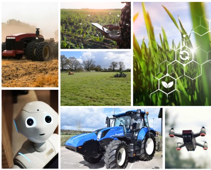
Precision farming technology has revolutionised agriculture, giving growers access to everything from GPS to variable rate mapping. CPM delves into the detail behind some of the most game-changing innovations on the market.
As we move towards the era of greater good, digital technology going to be fundamental in future-proofing farms.
By Charlotte Cunningham
Though much is unknown about how exactly the future of farming in the UK will look and work, everything we do know is pointing to the fact that greater resilience and sustainability are going to be core principles of viable businesses.
Of course, resilience and sustainability can mean many things, and future-proofing systems can’t be done by simply changing one aspect, however, precision farming technology and making better use of the data it generates present a good place to start.
Such is the view of Nicholas Saphir, the new chair of AHDB, who emphasised the importance of UK agribusiness being competitive – and how the productivity gap between the best and worst farmers can be narrowed by making better use of benchmarking and data – at the Agribusiness conference last month.
“These are exciting times, but it’s also going to be a period where uncertainty is going to rule and we’re going to have to find ways of being nimble and dealing with it.
“Farm success requires good agronomy and business acumen. The best farmers make more [money] and the worst do not. We must drive unnecessary costs out of the system.”
While potentially a controversial statement, it does open the discussion to just how best we can drive these “unnecessary costs” out of the system and what tools are on hand to help growers do so.
At the heart of precision farming is complex data-collection software, and while these platforms regularly face criticism for their lack of smooth two-way data transfer, progress is being made with the commercial launch of DataConnect – the cloud-based system that enables the exchange of machinery data between Claas, 365FarmNet and John Deere.
DataConnect enables the exchange of essential machinery data between different platforms, to allow users to view all of their mixed-brand fleet information within the single data platform of their choice. Previously, viewing such information required duplicating effort by using each manufacturer’s corresponding but separate platforms or web portals.
According to Deere, the structure of this new direct cloud-to-cloud solution enables a seamless and automated data flow without any effort required by the customer. The real-time data exchange allows a live overview of the whole machinery fleet. Furthermore, DataConnect works without any additional hardware and software components and ensures secure data handling.
With this new approach, customers can view five different machinery data sets for their fleet:
- Current machine location
- Historical machine location
- Fuel tank level
- Status of the machine in the field
- Machine speed
Customers can decide which company’s digital platform they prefer to use, to display all the data. As soon as they are connected, other manufacturers’ machines appear automatically. Machines are either displayed with icons in the respective brand’s colour combination or are visible in the icon’s information panel.
As well as this, Deere recently announced updates to its Operation Centre – designed to make the system “even smarter” and more compatible.
“Thanks to a new function, with just a few clicks all processes can be adjusted in the Operations Centre – even after fieldwork is finished,” explains Chris Wiltshire, marketing manager at John Deere UK and Ireland. “This allows farmers to manage operations just as flexibly as with a field book.
“If the tractor driver has accidentally documented the wrong crop variety during drilling, for example, this can easily be corrected later on.”
Further adjustments are also possible for worked area, plant protection products, tank mixtures, harvest year and crop calibration on the combine, among others. In the free MyOperations app, operators can also add data if they have forgotten to start the documentation or if the machine is not able to record data.
For customers with mixed fleets, the Operations Centre offers several options to import external data, says Chris. “For example, most common third-party displays can be connected using the respective ‘in-house’ format.
“Alternatively, data from machines with displays documenting the fieldwork in ISOXML format can be imported into the Operations Centre via a USB stick. This also works with historic machine data if it is still available somewhere else, for example saved on a computer hard drive.”
Even machines without a telematics system can be included in fleet management by using the optional location-sharing function within the MyOperations app. This function can be activated by the driver and uses the smartphone’s position to determine the machine’s location.
One of the UK’s biggest digital specialists, Farmplan, also recently announced a major update, which the firm claim will help growers unlock a decade’s worth of data.
The Business Manage update will allow users to view and analyse up to ten years’ worth of their data in just a click, giving farmers the chance to unlock extra value without requiring any additional input.
Business Manager users are now able to compare figures over a 10-year span both as profit and loss, and cashflow. Before, it was only possible to create comparisons between the current and previous year.
According to Farmplan, with this greater access comes greater insight – meaning farm businesses can measure their performance in the long-term and make more informed decisions as a result.
Behind the scenes, small tweaks have also made importing and exporting of data simpler.
Invoices and journals can be imported directly via CSV file – with members of North Herts Farmers now able to import their information directly, along with AF Group and Fram Farmers members – eliminating the need to enter data manually, saving time and resources.
And from one of the UK’s largest providers, to an interesting start-up firm that enables collaborative working to establish best use of land assets.
Showcased at Agri-TechE’s recent REAP conference, the Land App is a digital mapping platform that enables land managers to benefit from new agri-environmental schemes, connect with Natural Capital investors and design integrated estate plans that support best practice.
The company was founded by Tim Hopkin in 2015 out of personal frustration when he struggled to save the family farm. “I was trying to work out how best to use the land assets to stop us having to sell the farm and found the available information so fragmented. So, we started to develop software that would help pull all the data together.”
Not only did this enable Tim to keep the farm but now he has created a thriving business. “Our main objective with The Land App is to support the development of the natural capital market and the transition to agri-environmental schemes by improving decision-making. The platform facilitates the land management sector to work collaboratively and transfer land data more effectively.”
Looking at the technical side of things, the platform allows growers to pull in data such as boundaries, registry titles, Ordnance Survey data and Defra designations, and to build projects and schemes that support diversification by including farming and environmental activities, energy generation and alternative land uses.
And the real selling point? The platform is collaborative, allowing consultants and land managers to work together in real time to deduce the most effective use of the land assets.
“If an organisation is looking to fund new interventions in the landscape, such as a water company improving river quality or the Woodland Trust encouraging tree planting, we have so many land managers using the platform that we are able to inform them quickly of these opportunities,” explains Tim. “The software acts as a bridge between these multiple stakeholders in the land management sector to keep everyone on the same page and moving in the same direction.”
On the machinery front, while cost is undeniably a huge hurdle to overcome, particularly for smaller farms, the investment can bring a significant reward, according to Alessio Quatraro – connected services manage with Case IH’s parent company, CNH Industrial.
Alessio believes that with costs of inputs such as fuel, fertiliser and crop protection products continuing to rise, and wastage having cost and environmental impacts, both cropping and grassland farms – regardless of their size – can quickly recoup the cost of specifying or adding precision technology when ordering or upgrading tractors.
“Reduction in overlapping from the use of guided steering offers potentially significant savings in fuel and inputs such as seeds and fertiliser.
“But there are further benefits to be gained. For example, automated steering systems controlled by GPS improve accuracy and safety at night or in poor visibility. For grassland work such as fertiliser spreading where previous passes are hard to detect and measure against, they also make pass-to-pass accuracy of application simple.
And the more accurate the GPS signal used, the greater are the potential benefits to be gained, he adds. “While a basic GPS signal with 10-15cm repeatability will allow auto-steering systems to make parallel passes sufficiently accurate for tasks such as manure spreading, an RTK correction signal and the 2.5cm repeatability it provides offers the possibility of adopting controlled traffic, with the same tractor field paths used year-on-year, minimising soil compaction and maximising crop growth potential.”
Not only does the pass-to-pass accuracy of GPS guided auto-steering reduce fuel consumption and improve work rates, but the reduction in tiredness and increase in focus means more productive and also safer operation, particularly important for those working alone, he says.
Looking at this on a practical scale, Alessio explains that mid-range tractors such as a Case IH Maxxum or Puma – most frequently seen on medium-sized arable farms – are typically less likely to have been ordered with auto-steering. “These tractors – and the implements they work with – could be significantly more productive for their owners if specified with such systems.
“For example, by specifying ‘AccuGuide-ready’ when ordering such a tractor it will come with the necessary electrical and hydraulic components.
“It’s then possible to either specify the AccuGuide components, minimising installation time – the AFS terminal, navigation controller and AFS 372 receiver – to be delivered installed on the tractor, or to add them at a later date.
“Alternatively, the AccuGuide-complete option means a new Case IH tractor comes fully equipped with AccuGuide from the factory, allowing the user to take full advantage of auto-guidance from the day of delivery, using the armrest-mounted AFS 700 terminal.”
Recent Case IH developments have combined the functions of the independent HMC II headland management and AccuTurn automatic headland turn systems to create AccuTurn Pro headland turn management – fully automating operations at both ends and enhancing comfort and efficiency, says Alessio.
“With HMC II, once the driver has performed the simple process of programming a sequence of headland operations via time or distance – such as disengaging 4wd, raising the implement and switching off the PTO – a simple button press at the headland means all the programmed operations then occur automatically in sequence, with the reverse also possible when re-entering work. And it’s now possible to upgrade to AccuTurn Pro, which combines this with automated headland turning.”
Case IH AccuGuide-equipped tractors can receive a range of guidance correction, from the free EGNOS signal with its 20-25cm pass-to-pass repeatability, through Range Point RTX (15cm accuracy) to RTK + (2.5cm).
The repeatability provided by enhanced levels of accuracy also means that, for example, the same wheel tracks can be used when spreading fertiliser or liquid manure onto grassland, minimising trafficking of the land. Other possibilities include use of the same A-B lines when inter-row weeding a row crop that were originally set when it was established, he adds.
“Ultimately, there is a range of guidance technology that can bring benefits for small to medium-sized farms, particularly those with tractors run by owner-operators. These are systems that can return significant potential rewards for their investment.”
For anyone still on the fence about whether or not precision technology is worth the investment, Bayer launched a free trial of its FieldView in April this year – with growers still able to sign up until 31 Dec.
Bayer’s Max Dafforn says having access to these free trials are important as it helps for the trialists to see the full potential of digital technology. “We know from talking to farmers that many have lots of data but applying that to improve decision making doesn’t always follow. We want to make sure that those trialling Climate FieldView realise the capability of the platform to bring all their data together and then allow them to translate that into farm management decisions.
“Obviously, some growers are reticent of digital technology. But as we move towards the era of greater good it is going to be fundamental in future proofing farms.”
Inspiration from Africa
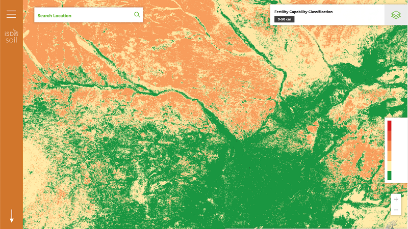
In a record-breaking announcement last month, Africa has become the first continent to chart soil fertility in every single field – the benefits of which are thought to have the potential to boost livelihood and human health across 54 nations.
The map has been produced by iSDA, a social enterprise founded by three research institutes – Rothamsted Research, World Agroforestry and the International Institute of Tropical Agriculture.
Their hope is to tackle the major human health challenges caused by food grown in poor quality soil, including the estimated 1.1M child deaths caused each year by malnutrition.
“For the first time, farm level soil data is now available for the entire African continent,” says Dr Jonathan Crouch, CEO of iSDA. “With an ever-growing demand for food, it’s critical that we find ways to increase productivity in sustainable ways that also allow millions of smallholders to improve their livelihoods.
“If we know the current status of essential soil nutrients, we can maximise productivity, profitability and environmental benefits.
From the Tunisian coast, all the way to the Cape – some 5000 miles away – the iSDA soil map charts the continent’s 3.4M square miles of potential agricultural land in unrivalled detail at roughly 24bn locations.
It means that for every single field on the continent, vital information such as the acidity, organic content, and nutrient levels of the soil is now available. This can help advise farmers in a number of different areas, such as yield forecasting, crop suitability and fertiliser application.
It also marks the first time an entire continent’s soil has been studied to this level of detail and raises real hopes for much improved harvests – and subsequently, the health, livelihoods, and food security of more than a billion people.
“Soils are fundamental to life on earth, but knowledge about African soil has been incomplete and out-dated,” adds Dr Matt Miller, lead data scientist at iSDA. “In order to continue to feed the fast-growing population sustainably, there is an urgent need to generate accurate, up-to-date soil health information to support agricultural development, environmental sustainability and fight climate change.”
How big is your footprint?
Not only does precision farming technology have the potential to improve productivity, but it can also help to curb the environmental impact of agriculture on the wider environment.
And in terms of carbon counting, AHDB has launched its first wave on-farm carbon footprinting, to help growers get a better understanding of just how much impact they’re having.
Chosen to represent a range of regions, systems and sectors, a total of 40 strategic and monitor farms will be the first to be assessed to determine their carbon footprint.
The assessments started last month, carried out by SAC Consulting and ADAS and will run until Mar 2021, with results leading to bespoke mitigation measures in detailed carbon action plans.
“The assessments are essentially the gathering of information – to identify and quantify all activities or inputs on farm that come with a carbon footprint,” says Dr Jonathon Foot, AHDB’s head of environment. “This can be anything from diesel, electricity, feed, and fertiliser and so on.
“Once this is established, we can then calculate the carbon to output ratio, i.e. how much carbon is being emitted per unit of output. This will then be assessed or benchmarked to determine where savings lie, and a bespoke plan created.
“Mitigation activities for arable could be as simple as changing cultivation routes to save on fuel or manure application times to optimise nutrient absorption.”
Tim Isaac, director of knowledge exchange at AHDB, adds that farmer input and actions are where the success lies.
“Implementing changes on farm can sometimes be a challenge and concerns are often raised about cost implications and wider impacts on productivity. However, evidence generally points towards ‘better for the environment equals better for businesses, so there are potentially benefits to be had all around.
“The key part of these assessments will be the identification of the specific measures the individual farms can take – while some will be unique to each one, we also expect some common themes to emerge. This will allow us to develop case studies and share practical tips and learnings widely through our knowledge exchange activity”.
The first cohort of farms will consist of 13 cereal and oilseed growers and the initial wave offers a springboard for more activity to be launched under the new five-year AHDB strategy being published later this year, says AHDB.
One to watch for…
Telus – the firm that recently acquired Muddy Boots – has recently launched Telus Agriculture, a new business unit with high aims to digitally transform global food systems.
According to the firm, Telus Agriculture optimises the food value chain by leveraging data in new ways to increase efficiency, production, and yields, delivering better food outcomes for businesses and the end consumers. As well as Muddy Boots’ involvement, Hummingbird Technologies has also partnered with the new division, increasing access for UK growers to this global platform.
At present, Telus Agriculture supports more than 40M ha of agricultural land, backed by a team of more than 1200 experts across Canada, the USA, Mexico, Brazil, the UK, Slovakia, Armenia, Germany, China, and Australia. “From farm to fork, by digitising the entire value chain and linking these technologies together for the first time, we will facilitate a secure exchange of information to allow farmers, agri-business organisations, the agri-food industry and the consumer to make smarter decisions” says Darren Entwistle, president and CEO of Telus. “Importantly, we are striving to provide innovative solutions to advance the agriculture sector on a worldwide basis.”