The rapid development of crop monitor and drone technology is helping farmers across the globe make better precision decisions. CPM takes a look at what’s new.
It’s especially important in this current COVID world, where agronomists and farmers aren’t necessarily able to meet face-to-face.
By Charlotte Cunningham
The driver behind most technological developments is to create something that makes day-to-day jobs and processes easier or more efficient.
This has certainly been the case for ag tech, with innovation helping us to do everything from variable rate applications, to even sowing crops autonomously.
When it comes to crop monitors and drone technology, rapid development and uptake is no doubt aiding better decision making for both growers and agronomists.
That said, knowing what to invest in can seem like a bit of a minefield, so to help growers get a better understanding of the options available, CPM has picked out some of the most recent launches and updates.
Omnia
Hutchinsons’ digital farming platform, Omnia, has recently launched a new version of the Omnia Scout app in a bid to make it easier for growers and agronomists to share crop walking information and update field records remotely.
According to the firm, the iOS app is a complete rebuild of the original Omnia Field Scout app, which allows growers to view the various layers of data stored within their Omnia account from an iPhone or iPad, and also update field records with notes, pictures, operational inputs or other information.
Providing there’s a data or Wifi connection, the app will automatically sync with the associated Omnia account as soon as information is added – giving instant access to field notes and observations, explains digital farming manager, Lewis McKerrow.
It also features an offline function whereby crop records can be downloaded in advance of going into an area with limited or no data connection, and any changes will be synced as soon as a connection is available.
“It provides a more professional, standardised way of making, recording and sharing crop notes from the field,” explains Lewis. “It’s especially important in this current COVID world, where agronomists and farmers aren’t necessarily able to meet face-to-face, so it should help strengthen these relationships.”
With increasing scrutiny of all crop inputs, particularly insecticides, the app also provides a digital record to help demonstrate the rationale behind input decisions and potentially allow more targeted treatment of crops.
Location markers can be tagged to any notes or pictures manually or by using the phone’s GPS, allowing that area to be revisited and monitored over time, and targeted management plans to be developed in Omnia if required.
Likewise, users can analyse data, such as satellite biomass imagery or yield maps, in Omnia and highlight specific areas for further investigation and “ground-truthing”.
Field information can be accessed and edited in a variety of ways through the app, such as by viewing all diary notes for a particular field, variety or crop type, adds Lewis.
“For example, you may find yellow rust present in one variety, so the app allows you to add this as a note to all fields affected.”
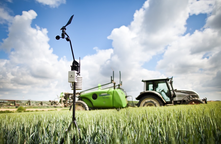
Sencrop
Also making upgrades to its mobile app is Sencrop, with the update now allowing customers to use their preferred weather forecast service from within the app itself.
Offering farmers an ultra-local, ‘smart’ weather service, Sencrop has more than doubled its UK station network over the past 12 months as more and more growers start to see the value of remote weather monitoring via a smartphone, says the firm.
Now the company has upgraded its mobile application, integrating the most popular weather forecasting models from the 22 countries where Sencrop has a presence and allowing farmers to pick the forecasting service most suited to their needs.
The move follows an in-depth customer survey conducted during Nov 2020, which revealed how users consulted and compared weather forecasts from different forecasting models every day.
Sencrop’s product teams then selected the most relevant models, according to three criteria – geographical coverage, short- or long-term forecast, and popularity – to develop the new feature, which was added to the Sencrop app at the end of Feb.
Within the application, farmers can access the forecasting models used by major UK weather data sites like Metcheck, BBC and Meteoblue, and use the most appropriate one according to their needs and preferences.
In total, 10 models have been integrated within Sencrop’s 22 active countries, including six for the UK and Ireland.
Sencrop says one model will be more relevant than another, depending on the use case.
A cereal producer may focus on short-term forecasts linked to wind, before applying nitrogen or crop protection treatments, while a potato producer will need longer-term rain forecasts to anticipate the risk of mildew. Similarly, wine growers will pay particular attention to short-term forecasts to plan for frosts in winter and thunderstorms in summer.
“Since our goal is to help farmers make better decisions based on weather data, and we listen a lot to what they have to tell us, we are continuously improving the Sencrop app,” says Michael Bruniaux, Sencrop co-founder.
“This further development in our forecast dashboard, which allows a farmer to pick the most suitable forecast model in their dashboard, felt like evidence to us. We realised this feature would be even more valuable if they could customise the weather forecast to the one that would most suit their needs.”
xarvio
BASF’s digital entity, xarvio, announced a number of new features at a recent ‘Big Data’ webinar, aimed at helping growers understand more about the technology available to help influence accurate on-farm decision making.
Among these is a buffer zone feature which is currently in development, with aims of being piloted as part of the Field Manager app in the UK this year.
According to xarvio’s Louis Wells, the aim of this is to make crop protection applications for products with aquatic buffer zones as easy as possible. “It will work by users entering information about the product they’re planning to use, the dose rate and nozzle type. We at xarvio would then bring in our knowledge and data around aquatic buffer zone regulations and water course locations around the field to create an application map for the users’ sprayer terminal, meaning that nozzles would automatically shut off when you’re travelling over the part of the field that has a buffer zone.”
As well as this, Field Manager in 2021 has also seen the addition of functionality including the option to add field notes for areas of specific interest, the ability to add management zones, as well as a whole host of new crops within its library.
Skippy Scout
On the drone front, weather patterns, varietal resistance shifting, and potential new races of rust have led some agronomists to use drone technology to identify the disease faster.
Among them is David Cairns, agronomist at MSP who’s started using Skippy Scout from Drone Ag to detect rust more quickly. “The past couple of seasons have seen yellow and brown rust become a greater concern. It’s important to keep an eye on this disease due to its speed of development. A small outbreak in a field can develop rapidly.”
A drone can take leaf level images of multiple points in a field in minutes – much quicker than ‘by-eye’ observation – and the images are detailed enough to identify early signs of many common crop diseases such as rust, he says. “Skippy Scout offers farmers and agronomists an opportunity to spot diseases faster. This can reduce the risk of irreparable damage to the crop and prevent yield loss, which will ultimately help farmers improve crop margins.”
Using a drone enables more frequent crop data to be captured and analysed. It also offers the opportunity to mark certain points in a field for more frequent monitoring, especially if a localised outbreak of rust is spotted, explains David. “It doesn’t replace conventional crop walking, but it does complement it. I can see more of the crop, more often, and I can revisit any areas of concern much more quickly and frequently.”
As we move into the depths of spring, depending on weather conditions, David says rust could appear quite rapidly and will need treating urgently. “Humidity is linked to rust with coastal regions being especially vulnerable, but all areas ought to be on guard.
“Despite efforts to grow varieties that are resistant, it is still strongly advised that crops are monitored regularly as new strains of rust are developing. “Crop walking can be hard, and spring is a busy time of year. That is why drone technology has been so helpful to my colleagues and I. I can view a crop ten times faster than on foot and the data is delivered in easy-to-read PDF’s that I can save and share.”
In perfect conditions, the complete rust cycle from infection to the production of new spores can take as little as seven days. This means that the disease cycle can be repeated many times in one season. “We know the scale of the problem and we should all be using every tool we can to minimise its impact on yield. Using drones to monitor crops and back up the work we do in the field has helped us spot rust early and protect crops more effectively,” he concludes.
Delving a bit deeper into Skippy Scout, a new version of the mobile app has been recently launched by Drone Ag. “Skippy Scout, version 2.5, is a big step forward. The original Skippy app could fly a drone to scout points in a field five times faster than traditional crop walking. The new 2.5 version has more functionality and is ten times faster, enabling users to cover up to 25 acres in just five minutes,” says Drone Ag founder Jack Wrangham.
Skippy Scout 2.5 offers field overview, automated scouting and PDF field reports using maps uploaded by the user, and images taken by the drone. “Our image analysis takes only minutes to provide an easy-to-understand report of the whole field,” he says.
These reports are generated using unique artificial intelligence (AI) interpretation to flag up potential crop issues and can also be compared to satellite and yield maps to find correlations in field performance. “It also provides a breakdown with indicators for green area index (GAI), healthy and unhealthy crop cover percentage, weed percentage, and it gives an insect damage measurement,” he says.
Users can therefore identify crop issues such as weeds or pests more quickly by subsequently viewing the leaf-level images on their phone or tablet. “Long term, the reports will also benchmark fields of the same crop to provide a picture of changes and crop progress over time,” he adds.
Existing users can update their app to version 2.5 for free now, and new users will benefit from all of the additional features when they register. “It is easy to start using Skippy. Anyone who owns a drone can sign up online with monthly subscriptions starting from just £30.”
Facilitating data exchange
As growers continue to battle the hurdles preventing seamless data exchange between monitoring platforms, Pessl Instruments has announced that its internet of things (IoT) and decision support system platform, FieldClimate, is now integrated with Microsoft Azure Farmbeats.
According to Pessl, this partnership enables farmers to make more data-driven decisions, and agronomists and researchers to build analytic models on top of aggregated data sets.
Fieldclimate was one of the first online platforms for collecting and displaying agro-meteorological data from tens of thousands of weather stations under the Metos brand, installed all over the world.
Azure FarmBeats combines data from different sources such as weather, visual information from drones and satellites and unites them with data coming from the Metos weather stations for data-driven analytics.
The selected Metos devices immediately sync as data flows into the FieldClimate servers.
According to the firm, collecting this data helps farmers to decide when to irrigate, when to spray, what disease preventive measure to take, whether conditions are suitable for particular activities in the field, and much more.
This helps to prevent unnecessary trips to the field, and saves money on fuel and other resources – from water to fertiliser.
With FarmBeats integration, FieldClimate can now leverage the FarmBeats soil moisture maps that are generated based on Metos device information and satellites.
“The collaboration between Pessl Instruments and Microsoft provides the opportunity to promptly identify problems, without visiting the field,” explains Gottfried Pessl, Pessl Instruments’ CEO and founder. “It can even provide greater accuracy than physical visits.
“The farmer and agronomist can install weather stations which monitor and alert them in real time about the actual field weather: temperature, relative humidity, rainfall, soil moisture, head units, wind gusts, evapotranspiration, frost and heat risks, forecasted frost and rains and many more aspects. The analytics from Microsoft Azure Farmbeats will provide the artificial intelligence so that all required actions can be taken on time and without delay.
“Knowing the climatic conditions is one of the most important aspects to consider in agriculture, climate change is a growing threat. Remote monitoring is not in the future; it is already in the present. The COVID-19 crisis has shown us how important food supply is and we cannot sacrifice any crop losses due to poor management or being unable to visit the field.”
Dr Ranveer Chandra, chief scientist, Microsoft Corp added that this data-driven agriculture and predictive analytics can provide granular and timely decision-making. “Effective data modelling in agriculture requires the ability to combine high quality data coming from sensors with widely available data from satellites and weather sources to increase the scale and accuracy of predictions.
“Pessl Instruments is a well-recognised partner with a large footprint of high-quality sensors in the market, and together we aim to bring the benefits of data and analytics to farming.”
Farmers and agronomists in the UK can acquire Pessl Instruments’ sensors from Metos UK.