Data could provide a gateway to endless advances in agriculture, however there’s increasing pressure to govern its use to make it safe for everyone. CPM attended the inaugural South West Agritech Showcase in Devon to learn more.
“The world is changing, and space is changing.”
By Melanie Jenkins
Agri-tech as an industry is growing at a rate of knots, promising to bring a raft of innovations that will improve efficiencies in farming, such as increased yields, optimised nutrient use, and aid cost of production.
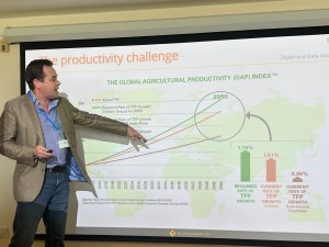
Julian Gairdner feels the lack of governance around data is hampering its usefulness to the agricultural sector.
But up until now a number of factors have held it back, including governance. Some might argue this is a double-edged sword, but Julian Gairdner of Communagator Consultancy believes it’ll help the industry develop.
“The UK agricultural sector has a productivity challenge to overcome,” he says. “We’re languishing behind a lot of our major competitors and, in some cases, our growth rate is less than half in comparison. There’s something systemic going on in terms of why the industry isn’t making the productivity gains that we’d like it to.”
But even globally to feed the growing population, there’s a big gap between the current direction of agriculture and where it will have to be, he adds.
“And then there’s the environmental challenge which is inextricably linked with productivity. As an industry, we should already be starting to work towards net zero targets either individually on the farm or collectively,” highlights Julian.
He also has concerns around carbon trading and natural capital due to the inadequacy of much of the verification and recording. “Farmers also have to be able to justify receiving subsidies and support from the government. And all of the above require good data.”
“We have to be able to evidence and prove the actions being taken both have benefits and improve the way we do things.”
Julian points out that there’s masses of data in agriculture which offers opportunities but, at the moment, the industry is just ‘scratching the surface’. “The things we’re going to be able to achieve with data are going to be massive.
“But one of the challenges we’ve got as an industry is to be able to take the information and data we already have and actually be able to convert it into something useful at farm level – to make it an actionable insight.”
Julien feels that progress with productivity is in some part being hampered by the technology, its interoperability, or lack of, and data standards. “But the other big piece is around governance because we don’t really have any.”
However, this is on the cusp of changing. “The British Farm Data Council was soft launched last summer with the aim of accelerating the digitalisation of the agricultural industry and to recognise organisations that are working responsibly, behaving well, looking after farmers’ data and being transparent in how they use it,” he explains.
“At present, the council consists of a number of volunteers who’ve come together to make something happen and there’s agreement that governance has to be taken more seriously. We haven’t got many safeguards in place and what does exist is fragmented. There’re lots of issues around trust and transparency.”
Currently, the council is focused on four key principles, he explains. “These are that the farmer’s data is the farmer’s data, that organisations will be clear on the value of any data collected, that they will keep data safe and strive to make the process easy.
“A lot of farmers are concerned that their data will either be used against them, or that it’ll be monetised and they won’t get any value back from that. However, I think this is currently more perception than reality.”
But Julian admits that a lot of farms still aren’t collecting data. “There’s an opportunity as an industry and from a policy level to incentivise farmers to do this. If we aren’t collecting data in the first place, then we can’t meet the challenges of the industry.”
The target for the council is to implement a code of practice to support industry that won’t be too burdensome, he adds. “The council is also looking at the experience of existing codes of practice in other countries, so there will be an opportunity to create some alignment to make future international cooperation easier.”
Eye in the sky
One area that is rarely observed physically but that has, for a long time, had a huge impact on day-to-day life is satellites. With circa 5500 active satellites already orbiting above the earth, and plans for tens of thousands more, their capabilities are only set to increase.
Sonia Pietosi of The Satellite Applications Catapult is helping to accelerate the use of satellite technology into UK agriculture. This is just one of nine government-backed Catapult Networks, each of which is directed at developing technology in a specific sector.
“Our remit is the space sector and satellite application,” says Sonia. “This includes providing independent advice for people who want to know how they can use satellite technology for their business and to overcome current challenges.”
The Catapult’s technology focus spans from strengthening the capacity to build and launch satellites in the UK, to increase the use of remote sensing data and communication capabilities in agriculture and for the environment, she explains. We’re going to have many more satellites launches, resulting in more frequent and varied data, plus the cost is massively reducing.
“Satellite technology can support agriculture and environmental sustainability, through positioning information, and the widescale use of observation data that satellites can provide on a regular basis. And of course, communication. This is crucial in agriculture, especially in remote areas which terrestrial networks don’t cover.”
According to Sonia, ubiquitous connectivity is particularly important in agriculture. “This means combining satellite and terrestrial services to ensure there aren’t black spots around the country. Having this kind of connectivity is particularly important to progress the use of robotics and drones, as well as for autonomous vehicles.”
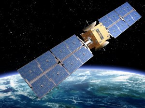
Geospatial intelligence involves satellites obtaining information on the Earth’s physical, chemical and biological systems.
Geospatial intelligence (also known as earth observation or remote sensing) is about obtaining information on Earth’s physical, chemical and biological systems from space, says Sonia. “We’ve seen a growing availability of information that is accurate, localised and personalised which is available globally in almost real-time.”
Remote sensing from satellites is already providing weather forecasting, variability mapping, irrigation management, soil mapping, crop growth monitoring, fertiliser application and is able to record instances of pests and disease, she explains.
Sonia often gets asked how satellites are able to collect this data. “It lies in the electromagnetic radiation spectrum whereby light is reflected in a unique way. From space we can read this and detect different elements.”
One exciting area of development in this field is in the detection of carbon, methane or phosphates, for example, she says. “We’re now looking specifically at how to detect these and, in the future, there’ll be satellites launched specifically to detect these in the electromagnetic spectrum.”
Satellites are already being used to track and trace produce to link up the food chain. “We’ve already implemented a project called Trusted Bytes in collaboration with University of Lincoln to this effect.
“The world is changing, and space is changing. The combination of these capabilities really helps us with future use cases such as nutrient pollution in water, regenerative agriculture, biodiversity, rewilding, carbon sequestration, autonomy and interoperability,” she says.
This is where the Environmental Living Lab comes in. This will be launched at the end of the summer and aims to help push the boundaries of research in the South West, but it’ll have country-wide impacts. “These are innovation services which co-create transformative solutions to real-world agricultural and environmental challenges using satellite technology.
“Our vision of transforming agriculture and the environment won’t be achieved if we don’t help businesses commercialise and scale and at the same time, increasing the adoption of these solutions by farmers and land managers,” says Sonia.
The Soil Association is already working on a project using satellite information to create a digital copy of soils, says the organisation’s Katy Jo Stanton. “The project, AI4SoilHealth, links biodiversity to ecosystem services and then harnesses artificial intelligence (AI) technology to accelerate the design, collection and interpretation of that information,” she says.
Currently the project is operating on 14 sites across Europe and is taking data from as many sources as possible, explains Katy. “Working with Planet, a new satellite is being launched to feed high resolution data into the project. Mapping and data from research institutions will be combined in a data cube to make a digital soil twin.”
Over a four-year period, data will be fed into the digital twin that can then be used to make things like mobile phone apps, data layers, soil health toolboxes and more, she says. “What’s exciting is the application programming interface in the middle of this, can be publicly available in the future.
“Understanding what’s happening on the ground against past data sets is going to enable us to build more robust predictive analytics and that’ll aid decision making in the future,” she adds.
This article was taken from the latest issue of CPM. For more articles like this, subscribe here.
Sign up for Crop Production Magazine’s FREE e-newsletter here.