Ever wondered what your soil is trying to tell you? CPM profiles a new service, using a tool that picks up a soil’s unique signature to give a window on its world.
For me, that’s what’s exciting – using the technology to unlock the secrets of the soil.
By Tom Allen-Stevens
A certain amount of care is applied as the sodium-iodine crystal, encased in its carbon fibre tube, is placed in the foam-filled carry case, ready to move to the next site. It lies at the heart of what Hutchinsons believes is a “game-changing” soil-mapping service, that will quite literally unearth a wealth of spatial data that’s never before been captured.
“A lot of farmers have already used precision farming technology to make the big gains, through nutrient mapping and soil conductivity scans,” says Hutchinsons precision technology manager, Oliver Wood.
“TerraMap delivers the data behind that in far higher resolution and sets a new standard for accuracy. But it has the potential to go much further – many growers are now looking for the marginal gains that will lift them off the yield plateau. For me, that’s what’s exciting – using the technology to unlock the secrets of the soil and working with growers to understand how to use the information to optimise crop performance.”
What the crystal does is pick up unique signals, emitted by the soil, as it passes over the surface. The Terramap service turns these into data from over 800 points/ha, providing high definition mapping of all common nutrient properties, pH, soil texture, organic matter and cation exchange capacity (CEC) as well as elevation and plant-available water.
The results from TerraMap are used to create maps within the Hutchinsons Omnia system that now has over 620 UK users covering 375,000ha. The soil-specific data generated can be overlaid with additional field information such as blackgrass, yields and other data, to create accurate, consistent and detailed variable rate plans, explains Oliver. “You can also export the data in industry-standard formats for use in other software packages.”
But precision soil-mapping is nothing new, so what’s different about Terramap? “There are currently two methods used globally for soil mapping,” he says. “With the grid system you create a 100x100m grid across the field, taking samples at each point. A map is then generated that extrapolates properties between the data points. A zonal system uses an electro-magnetic (EMI) or conductivity scanner to assess soil properties into zones of similar character. Samples are then drawn from within each zone.
“The resolution isn’t good with the grid system – the way the smoothing is carried out by the software between data points can be quite crude. The problem with EMI scanning is repeatability – it’s massively affected by soil moisture, so the picture you get of your soil in Sept can be completely different to a scan taken in April. The zonal sampling resolution also tends to be poor – on average one sample represents 2.5ha.”
Terramap uses completely different technology to assess soil properties. “The sensor isn’t new – it’s a scaled-down version of airborne sensors that have been used in mineral prospecting for many years – but it’s only recently been adopted by the agricultural industry.”
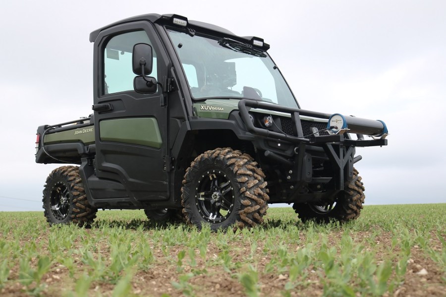
It’s a gamma ray spectrometer, mounted on a UTV, that passes no more than 1m above the ground. Inside is a sodium-iodine crystal that’s sensitive to naturally emitting radionuclides – signals continually beamed out by the soil that could be considered its way of communicating. These “flashes” are then picked up by a photo-multiplier tube.
“It’s an entirely passive sensor, so you can travel from harvest through until March without disturbing an autumn-sown crop,” continues Oliver. “It picks up the unique radioactive signature emitted by the soil that’s influenced by its nutrient and mineral content. That signature can be translated back to the core properties.”
And this is where the clever bit comes in. The system has been developed by SoilOptix, a Canadian concern that launched the service to farmers in 2010, and it’s their analysts who crunch the data. Although the spectrometer itself is a fairly standard piece of kit, SoilOptix has put years of testing and proofing in commercial use into the algorithms it’s developed.
“What we receive is meaningful, useful information for farmers,” says Oliver. “This is its first application in Europe and Hutchinsons has exclusive rights to the service in the UK.”
Just like EMI scanning, the sensor has to be ground-truthed, so soil samples are taken within each field to help the algorithms align the radioactive signature to the actual soil properties. But unlike EMI, that signature remains the same and unique to the point in the field, regardless of moisture and temperature.
“Repeatability is one of the key aspects we’ve been testing since we first started using the technology almost a year ago,” notes Oliver. So several fields scanned just after harvest last year, when they were dry and in stubble, were re-scanned as soon as they were fit to travel in early spring. “The results are virtually identical – we have real confidence the scanner is measuring something repeatable.”
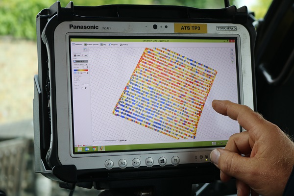
It’s also a one-pass system. Just like an EMI scan, the field is travelled in 12m bouts, explains Alan Christie of Agri-tech Services, contracted by Hutchinsons to do the field work. “The initial scan gives you a map of the raw data points that are displayed on a tablet in the cab. But unlike EMI, the on-board software then uses that information to highlight points within the field to return to for detailed analysis.”
Before leaving the field, the sensor is returned to a number of pre-defined sampling points, each representing around 3-4ha. “At these points, the spectrometer picks up a more detailed signature and we take a representative soil sample for later analysis.”
When the data comes back, there’s a level of interpretation that’s crucial, and best carried out with your agronomist, says Oliver. “Within the industry, sometimes variation is shown just for the sake of it, and it’s important to use the right scale. For example, you can generate a detailed map of a field showing how the clay content varies from 5.6-9.9%. But that level of variation isn’t actually significant in practice.”
The system’s been put to use on Thurlow Estate, which has arable land spread over six farms across 5000ha of Essex, Suffolk and Cambs. Many of the fields were EMI-scanned in 2012, but some of the results have always been viewed with a level of scepticism, says Jim Woodward of Farmacy, one of the estate’s agronomists.
“The EMI scan is one-dimensional and doesn’t really tally with what’s going on in the field. That’s probably because it only looks at clay content.”
There’s a large chalk content in the estate’s soils that he believes could interfere with the scanning. “But this doesn’t appear to have happened with the Terramap survey. The results, particularly on soil texture, look impressive and seem to be more accurate than previous results.”
Jim’s been using precision farming technology to inform decisions for over 25 years. “We started using it on a rotational basis to tailor P&K applications. Nowadays the main entry point for most is variable-rate seeding, and the soil texture map in Terramap should give us more accurate variable rate plans, especially on chalky soils.”
He believes there’s potential for the system to inform in-season decisions, however. “Within the crop, currently the only input that’s really varied is N, and this is informed entirely by assessing green leaf area (GLA), through NDVI maps, for example. But GLA variance could be down to varying magnesium levels, or some other soil-related factor.
“This gives you the ability to interrogate through layers, and as the season progresses adapt the agronomy by zones – so what you can do to improve rooting, for example. Taken together, all this data is far too much for the human brain to process and generate a spatially varied plan. But it’s something that could be done by artificial intelligence, informed and interpreted by sound agronomic knowledge.”
This is already being explored through Project Helix, Hutchinsons’ testbed for novel scientific applications and digital farming. One of its three major themes is Project Nutrition, and eight fields have been mapped using Terramap with the specific purpose of using the information as the cornerstone to develop bespoke nutrient plans.
“This is starting to awaken minds within our team of agronomists, and I hope it will do the same for growers,” says Oliver. “We’re just starting on a journey and realising the wealth of information we now have on our soils. The plant-available water index is the layer that for me is the most exciting. I can see that it’ll be used in really creative ways in conjunction with other data to inform some sound ideas and respond more closely to a soil’s true nature.”
- Terramap will be launched at Cereals. Visit the Hutchinsons stand for more information or contact Omnia Services Centre on 01526 831000.
Exploring the layers that define a soil
Terramap will be available at two service levels: Standard will deliver nine map layers to the grower, directly replacing other soil services currently available (although at higher resolution and more accurate, says Hutchinsons). Pricing for the standard service is similar to other services at £24/ha. The Premium service will deliver 21 map layers for an extra £8/ha.
Standard
This brings in sand, silt and clay content, giving you individual layers of percentage content, as well as a texture map, calculated using the industry-standard soil texture classification. For Omnia users, it will be the soil texture layer that’s used in combination with seedbed condition, weed and slug pressure to generate a variable rate drilling plan.
In addition, phosphate, potash and magnesium index maps are returned, along with pH, while an elevation map is also generated. The nutrient and pH layers will directly inform variable rate application maps.
Premium
These are the layers you won’t get from a standard precision soil-sampling service, says Hutchinsons. They include levels of the nutrients calcium, sodium, sulphur, manganese, boron, copper, zinc, molybdenum and iron. It’s seen as unlikely that growers will use the maps to variably apply micronutrients. More likely, the information will be used with tissue testing, for example, to identify potential areas of deficiency and to target areas for further investigation.
Organic matter levels and cation exchange capacity (CEC) are two further layers of “good background information” returned by Terramap. Again, it’s unlikely growers will use the information to directly spatially apply inputs, says Hutchinsons, although it may indicate areas that warrant further investigation. The value in the maps may come through the barometer they offer on general soil health, informing how to build resilience into the arable system, and as a basis for applying for future subsidy payments linked to provision of public goods.
The final layer is plant-available water, calculated by SoilOptix based on clay, silt and organic matter content. In the first instance, this could help modify irrigation scheduling, but Hutchinsons believes the information can be used to tailor agronomy closer to crop potential, enhancing overall performance.
There’s potential in the unexpected
In the Scottish Borders near Berwick, Jorin Grimsdale of Mountfair Farming has been looking at ways to progress the business’ 2200ha of arable cropping.
“We’ve been using zonal testing for some years to test nutrients along with EMI scanning to assess different soils. This has worked very well, but we’re looking for the next evolution of data, trying to get more layers and find out more about what’s going on with our soils – to get more detail,” he says.
Winter wheat, spring oats, spring vining peas and some beans make up the arable rotation. Earlier this year, 125ha of the soils were scanned using Terramap. “We now have the results, and it’s been extremely impressive,” reports Jorin.
Working with Hutchinsons digital farming manager Lewis McKerrow, the data generated was combined with other information, such as yield maps, and biomass layers. “This allows Omnia to do what it does best, which is multi-layer decision making,” says Lewis.
For Jorin, it’s delivered on the expected soil properties. “The Mountfair strategy incorporates organic manures throughout and Omnia’s ability to assist in managing this process with the new higher level of detail Terra-map collects is a great step forward,” he says.
“But it’s also shown a lot of aspects we weren’t aware of, such as different nutrient contents we’ve not measured before, as well as detail in layers we’ve not seen.
“Cation exchange capacity, water availability, organic matter, molybdenum, boron, zinc – Terramap’s created layers with this data, as well as the standard P, K and lime layers we were expecting.”
The standard layers will be used to inform routine P&K applications, which are applied variably, while information on soil texture is used within Omnia to generate variable rate seed plans.
“It’s brought together a massive amount of information and the intention is to use this as best we can to learn, and then to see how we can adapt our farming operations,” notes Jorin.
“What I like about Terramap is that it works within Omnia, and it provides a high level of information in much more detail from a one-pass soil property collection system.”
Digital Direction
As arable farms progress towards a digital future, it can be difficult to know which forms of data generation, capture and analysis provide a really worthwhile benefit to the business, and which are costly and time-wasting distractions. CPM is working with some of the industry’s leading companies in this area to bring growers some Digital Direction. These articles track the significant steps on the journey towards the data-enabled farm, and also explain and profile the technologies involved.
CPM would like to thank Hutchinsons for sponsoring this Digital Direction article and for providing privileged access to staff and material used to help bring it together.
As a business Hutchinsons continues to invest heavily in all areas of research and development, and precision technology is a key part of agronomy for the future to ensure economic performance and environmental sustainability of agronomy advice.
It is as a result of this approach that Hutchinsons developed Omnia Precision Agronomy which is a key focus for the business going forward.