As costs come down, the potential uses for unmanned aerial vehicles are multiplying and the information they generate is increasingly useful. CPM gets a demonstration and explores some of the services available.
The view from 50-120m above the crop is one that few farmers have seen before.
By Tom Allen-Stevens
The rotors twitch and the green and red lights illuminate. There’s an under-hanging gimbal that swivels round to put the quadcopter’s all-seeing eye into position and it gives a beep to signal it’s ready to launch.
Then the rotors on the DJI Inspire I quickly whir to full speed and lift it effortlessly off the ground, and as the camera swings round and seems to fix you in its gaze, you’re caught between two thoughts – this is spookily like something out of a 1980s sci-fi film, but then, isn’t this the toy you always dreamed of having?
Unique viewpoint
“Unmanned aerial vehicles (UAVs) may now be low-cost technology, but they’re better than toys,” says Jim Wilson of precision farming specialists SoilEssentials. “They can offer farmers and agronomists a unique viewpoint and
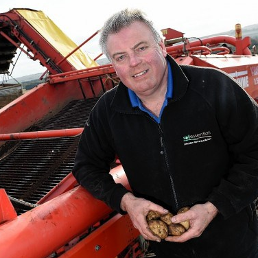
Jim Wilson reckons the best route is for the images to be taken by the farmer or agronomist then uploaded to a web-based processing service.
resolution to improve crop scouting and problem detection.”
He’s been using UAVs for precision farming services for the past two years, using radio-controlled models and aerial imagery before that. Along with Deimos Space UK and G2Way, SoilEssentials is also part of the KORE (Knowledge, Observation, Response, Evaluation) project from ESA (European Space Agency), that aims to help farmers incorporate satellite imagery with data captured from UAVs and tractor-mounted sensors and put them to good use.
“Poor performing areas, crop problems, weed patches, soil-borne pests and drainage problems can all be clearly and easily identified from the air. You can record these zones and use them to generate variable rate application (VRA) maps or just to keep a permanent record.”
The eye-in-the-sky view isn’t unique – such imagery has been available for decades via satellite or aerial services. But the view from 50-120m above the crop is one that few farmers have seen before, notes Jim Wilson.
“It’s cheaper and much lower cost than satellite imagery, although there are times when the latter is a better option. The resolution is much higher with drones – cm level, while satellite images give you metre resolution – so crop problems can be identified with a much greater level of accuracy. Also new tools can be run on this high resolution imagery to provide new agronomic information, such as plant counting.”
Data interpretation
But there are two aspects to making the most from UAVs – the hardware itself and the interpretation of the data. So the KORE project has provided ten farmers and agronomists across the UK with UAVs. In addition, there’s a customised web page where they can plan flights, upload imagery, view UAV and satellite imagery of their fields, mark crop problems and create VRA maps. “This means they keep costs to a minimum and start building up a history of their own field imagery, which can be shared with agronomists and clients,” notes Jim Wilson.
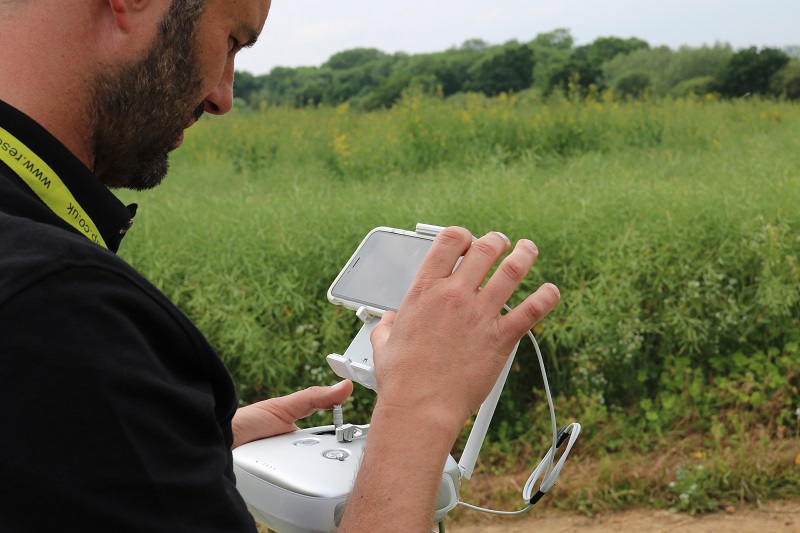
App-based software running on your smartphone or tablet usually controls the UAV.
The UAVs themselves start from as little as £200, which gets you a drone with its own camera to fly around your farm. “You can use this for simple crop-scouting, roof inspections, chasing deer and pigeons and making cool videos of machines working. Sometimes the video is sent back to the operator in real time (known as first-person view) so you can guide the drone to what you want to see. But it’s usually set up with a camera that looks obliquely across the crop so it doesn’t get the best view of crop variation.”
Spend more than £1000 and the functionality, flexibility, and level of automation increases. The market-leading DJI Phantom and 3DR Solo models, for example, have a camera mounted underneath so they can look directly down onto the crop. Automation is built in that makes flying the drones easier, with take-off and landing done for you, while some models will fly back to land when the battery runs low and can even sense and avoid obstacles.
App-based software running on your smartphone or tablet usually controls the UAV and allows you to set it in either first-person view or survey mode. The latter is where the drone completes a pre-planned mission which triggers the camera at pre-defined waypoints.
These pictures can be uploaded to a cloud-based processing service where they’re ortho-rectified, georeferenced and mosaicked – stitched into a map. What you then get back can be imported straight into your mapping software and used to generate VRA maps.
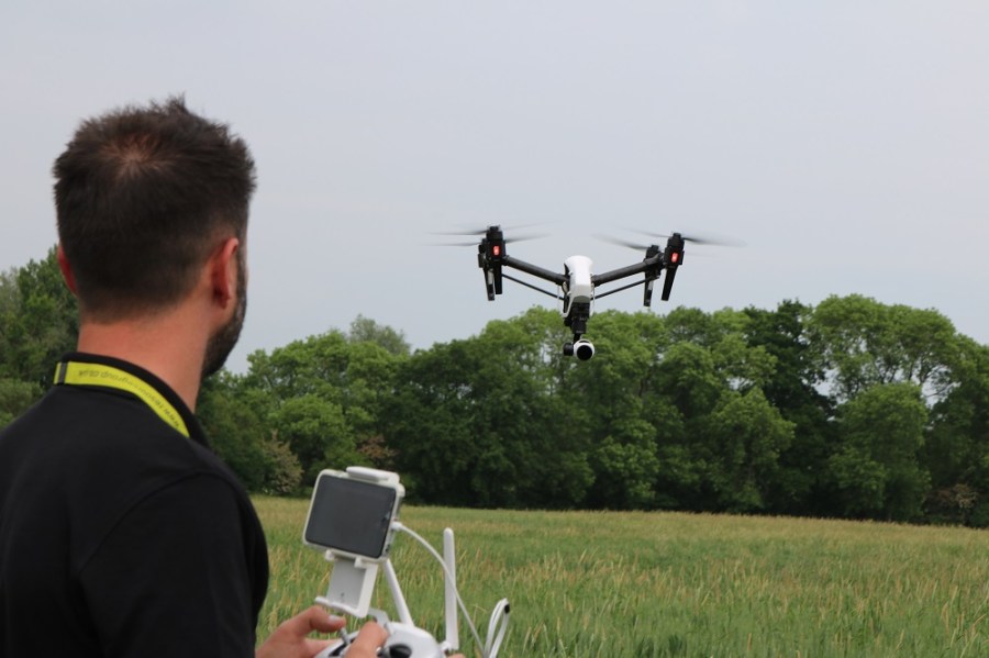
And that’s the job that’s been assigned to the DJI Inspire quadcopter, piloted by Geo-4D’s Simon Belmont. After a few majestic sweeps over the crop at low level, he puts the drone into survey mode and it climbs to 50m to start the scan of the crop.
Although he makes it look easy, Simon Belmont’s a fully qualified pilot, with the Civil Aviation Authority (CAA) Permission required to run the drone on a commercial basis – he also works as a pilot for Virgin Atlantic.
“You get about 15 mins of flying time out of a battery, that’s enough to survey about 10ha. There’s a 12-megapixel camera and you can shoot video in 4K, so the quality of the images is very good. What’s more, the gimbal and set-up of the machine take out any blur or shake you might get with cheaper kit.”
Geo-4D is a geo-consultancy that uses a range of aerial and terrestrial survey equipment, including UAVs, to provide land surveys, technical inspections and visualisation services, to a number of different industries. The team specialises in producing 3D models and full GIS analysis of sites to capture all types of geographical or spatial data, explains the company’s director Brian Critchley.
“We can provide drainage analysis, chlorophyll-reflectance mapping, using multispectral data capture, index calculations, such as NDVI (Normalised Difference Vegetation Index) for crop health and weed mapping,and biomass estimations. We use specialist software packages to process the data to assist with on-site decision making.”
Specialist area
It’s when you move up into this level of sophistication that the costs begin to mount, and it becomes a more specialist area. “The multi-spectral camera we use for NDVI retails at around £4000. Then the software package we
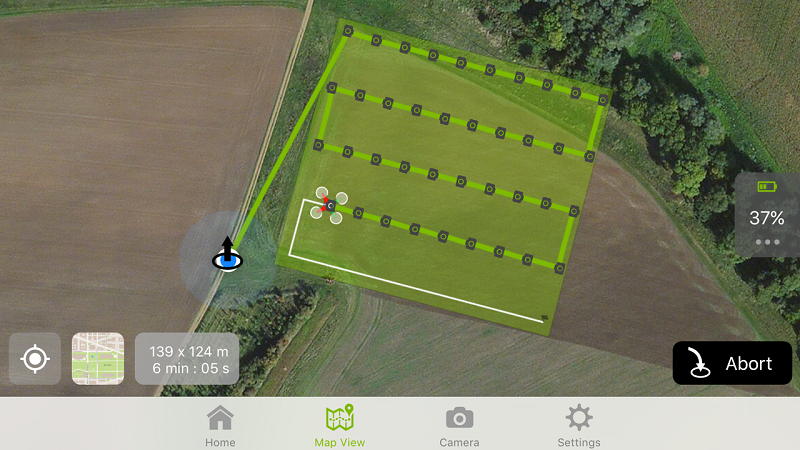
In survey mode, the drone completes a pre-planned mission which triggers the camera at pre-defined waypoints.
use costs around £5500,” he adds.
There’s also a bigger UAV – the SteadiDrone – that can take a higher payload, such as an SLR camera that can zoom in on hard-to-reach places. “We can use it to take pictures of hairline cracks in wind turbine blades, for example,” says Brian Critchley.
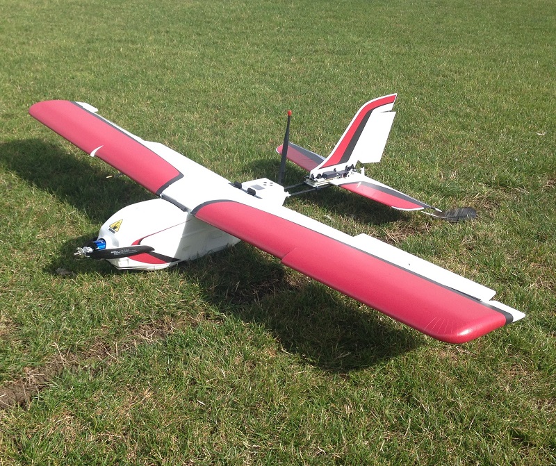
Finally, there’s the fixed-wing UAV, a more specialised piece of kit that can cost up to £15,000, although Geo-4D’s version is a cheaper model, at around £3000, notes technical manager James Fleming. Like other UAVs it runs in survey mode, but requires a high degree of technical skill to set up and control – a glitch with the circuitry keeps the UAV grounded for almost an hour before it’s ready to launch.
“The camera is fixed and points straight down, but the UAV can be set on a pre-determined route and takes very accurate, good quality pictures – we use it to generate 3D models of landscapes,” says James Fleming. With a flying time of around 45mins from a fully charged battery, it can survey around 100ha.
So what’s the best way to get started? Jim Wilson reckons it’s not a bad idea to get a season’s experience with a low-cost UAV, using it for little more than basic crop-scouting.
Rules and regulations
“Then, if you want to use the maps for precision agronomy and proper crop scouting, you’ll need a UAV capable of generating the imagery, with help and support to process the data. Don’t be afraid to play and experiment, but remember the rules and regulations from the CAA.” (See ‘staying within the law’ text below).
Plenty of companies now offer UAV-based services for those who don’t want to buy the kit, or don’t have the time to acquire the skills and permissions to operate it. This may bring a more professional result, but it relies on conditions being right on the day of the flight, points out Jim Wilson.
“The only way I can see the economics working long term is if the images are taken by someone already on farm, like a farmer or agronomist. Then they’re uploaded to a web-based processing service and the user is notified when they’re ready, can log onto their account and can start to put the images to good use,” he says.
Staying within the law
Drones can cause injury or damage if they’re not used responsibly and so are subject to safety rules, which are underpinned by UK law.
Do I need CAA Permission?
This is effectively a licence to operate a drone, known as a Permission for Aerial Work (PFAW) that must be renewed every 12 months. If using a UAV purely for recreational purposes on your own farm, you probably don’t need it. But if it’s used for any commercial work, you will. What’s more, you need CAA Permission to fly a drone within 50m of a building or 150m of a congested area – that can include an event, such as a country show.
You need to demonstrate understanding of aviation theory, pass a practical flight test and produce an operations manual detailing the type of flights you want to do. Courses are available which would gear you up for your PFAW, and these vary from one to three days long. The PFAW itself costs £112-224.
What are the safety guidelines?
UAV use is covered by regulations contained in the Air Navigation Order. You mustn’t allow it to endanger any person or property, and should always keep it within visual contact.
You’re not allowed to fly it near airfields, in controlled airspace without clearance from the appropriate air traffic control unit, or more than 122m above the ground.
What about privacy?
You shouldn’t operate a UAV with surveillance equipment within 150m of a congested area or within 50m of a person or vehicle unless they’re ‘under your control’.
Generally, an employee driving your combine, whom you’ve briefed prior to a fly-by as part of a video shoot, would probably be considered ‘under your control’. But a crowd of people at an open-air event, your next-door neighbour sunbathing or a walker on your farm you’re keen to feel unwelcome, probably isn’t.
For more information, go to http://www.caa.co.uk/Consumers
Agrovista launches variable nitrogen UAV service
A new pay-as-you-go variable nitrogen-assessment system has been launched by Plantsystems, the technology arm of Agrovista, the first unmanned aerial vehicle (UAV) service offered by the company.
One of Agrovista’s CAA-qualified operators will visit the farm to capture the data with a Precision Hawk UAV.
Lewis McKerrow of Agrovista says the service is suited for those who can’t justify the investment for a tractor-mounted crop sensor, such as the N-Sensor, or who have been disappointed with the reliability of satellite imagery.
“The farmer books in the fields he wants assessed with Plantsystems and one of the company’s Civil Aviation Authority-qualified operators will visit the farm to capture the data,” he says.
The data will usually be processed overnight and will be available the following day. Plantsystems can then deliver it back to the farmer in a number of ways, he explains.
“Those with the correct software can receive a shape file of the data, which requires the grower to attribute a spreading rate to each zone. For those without the software, we can upload the data to our web-based Axis MapIT Pro platform, ready for the rates to be added to the spreading zones.”
Some farmers may prefer the spreading files to be sent ready to load into the spreading equipment. “We can do this once the farmer or agronomist tells us how much nitrogen the thickest and thinnest parts of the crop should get, or the average rate and percentage variation,” says Lewis McKerrow.
“Our philosophy is that the nitrogen rates should be decided by the appropriate person,” he adds. “We’ve seen some systems that provide the farmer with a suggested rate of nitrogen, but we believe there are too many unknowns that could lead to inaccurate recommendations, such as residual fertiliser in the soil, NVZ limits and end markets. The human input is still an important part of the equation.”
To capture the data, a single visit at about GS31 appears to be the optimum, he says. “That’s looking like the best timing to provide enough information on which to base the main nitrogen dose and the final dose.”
Growers who sign up to the service can expect returns similar to other variable nitrogen systems. “Typical yield increases are 3-4% without using any more fertiliser,” says Lewis McKerrow. “On an average winter wheat crop at current values, that’s a £30-40/ha increase in profit.”
The cost of the service will depend on the area to be surveyed and starts at just below £10/ha, with bigger jobs attracting a discount.
“The biggest cost is getting the person to the site and setting up. The more hectares we can fly, the more cost effective it is to the farmer.”
Aerial crop spraying is back
Drone AG announced a new drone-based spraying system at Cereals 2016. Targeted and precise application of pesticides and nutrients via drone systems is the promise from the company, that can be combined with its drone-based mapping services. This allows for a full identification and treatment system for applications such as bracken control and targeted blackgrass eradication. You can spray hard-to-reach areas and places vehicles can cause damage. Services will begin in Aug 2016 with systems available from Sept.
Use of UAV technology takes off
Precision crop production specialist Soyl has seen a steep increase in the number of farmers using its UAV-based services, according to commercial director, Simon Parrington.
“Our flight operations team have had their busiest six months since we gained CAA approval to operate UAVs three years ago. Demand for the type of information they can provide is up 300% on last year already and we believe this is just the start.”
Easier operation, increased flight times and simple processing now available in the technology mean Soyl can more easily translate the resulting data into advice and specific crop prescriptions for growers, he says. “Most of the demand is coming from larger growers, often growing specialist crops but we’re also providing data to companies running replicated trials research.”
Andrew Hartley, national trials manager for Frontier uses information gathered by a UAV, and interpreted with Soyl, to help assess trials plots. “The ability to look from above, use different types of cameras and capture and compare images opens up many more research possibilities. It also means we can verify data we’ve already gathered in the field and pick out differences that wouldn’t be visible from the ground with the human eye.”
Soyl offers a range of UAV platforms and sensors and helps farmers use the technology through three services:
- Sight – For broad-acre arable crops where rapid data collection over blocks of land 200ha+ is typically used for weed and disease identification. This is high daily output and medium resolution.
- Plot – Offering and improving accuracy and efficiency of routine measurements such as biomass, crop height, establishment and responses to treatments.
- Sight+ – Plant counts and automated quality measurements to improve harvest planning and efficiency.
Simon Parrington reckons it’s important to offer more than just the UAV service. “We don’t just organise and carry out the aerial data collection, we then have the precision technology and agricultural expertise to analyse and interpret that data into advice and prescriptions,” he notes.
The company has also launched a new app which it says will make recording, monitoring and review of in-field problems and variations much easier. The iSoylScout is a field scouting app for iPhones and iPads which allows growers, or anyone else helping to manage the business, to log features and problems on the land while they’re actually in the field. The app is fully integrated into Soyl’s online data portal MySoyl, so information is transferred quickly and easily via the cloud.
The new app complements the company’s iSoyl variable-rate app says Simon Parrington. “Growers could use the new app to note patches of blackgrass so they could refer back to the information later when making spraying plans, or log the location of natural features such as trees or ponds which will help when creating crop protection application plans perhaps months or even years later.”
You can accurately record the location of features, while a manual drawing function can be used to add a new feature. The app tells you the measured area of the recording and allows you to edit the area. “This is especially useful if a farmer needed to create an area of wild bird seed of 1.0ha, for example. The app will note this and help the grower accurately set out and record the exact area.”
Once uploaded to MySoyl, all those with permission to access the account can then see the areas, points, comments and photos that have been recorded.