Precision agriculture has been changing the way we farm in recent years. However, with new developments coming onto the market almost on a weekly basis, keeping up with the latest technology can seem like a bit of a headache – but could potentially mean growers are missing out on new, innovative solutions that could help progress their business.
CPM takes a look at the unique new soil mapping service from Hutchinsons, which promises to deliver a greater level of accuracy than ever before.
By Charlotte Cunningham.
Soil mapping is nothing new – growers have been embracing the technology for a number of years in order to give them a greater understanding of what is going on below the surface. However, the recent launch of the Terramap service from crop production specialist, Hutchinsons, is set to deliver an even more in-depth level of detail. So how exactly does it work?
TerraMap uses gamma-ray detection technology to deliver resolutions of over 800 points per hectare, providing high definition mapping of all common nutrient properties, pH, soil texture, organic matter and cation exchange capacity (CEC) as well as elevation and plant available water.
“A lot of farmers have already used precision farming technology to make the big gains, through nutrient mapping and soil conductivity scans,” says Hutchinsons’ precision technology manager, Oliver Wood. “TerraMap delivers the data behind that in far higher resolution and sets a new standard for accuracy.
“But it has the potential to go much further – many growers are now looking for the marginal gains that will lift them off the yield plateau. For me, that’s what’s exciting – using the technology to unlock the secrets of the soil and working with growers to understand how to use the information to optimise crop performance.”
Data from TerraMap is used to create field maps within Hutchinsons’ Omnia precision farming system, currently used by 620 UK farmers covering 375,000ha. The maps can be overlaid with additional crop protection and management information to create accurate, consistent and detailed variable rate plans.
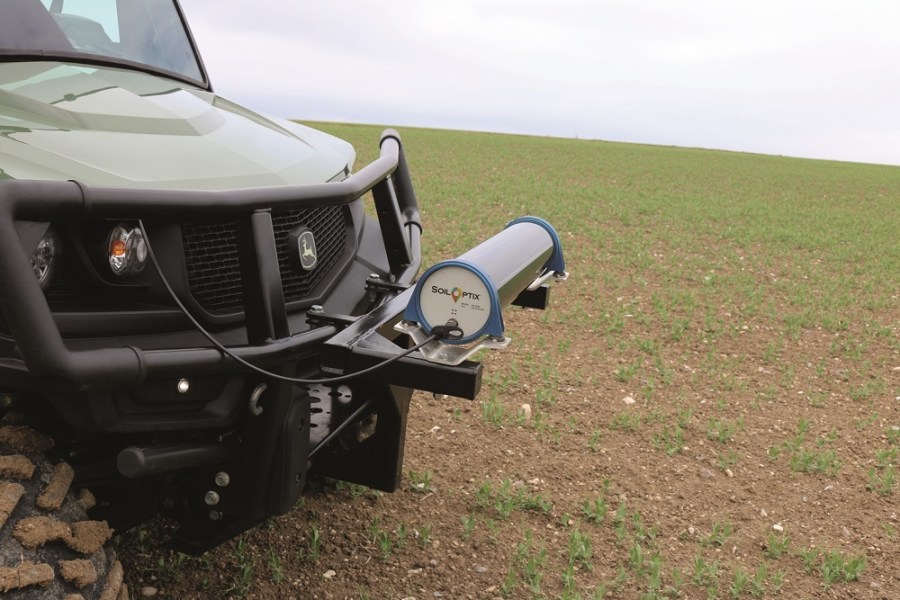
The data collection involves two steps – scanning via a lightweight all-terrain vehicle over a field, plus soil sampling to allow for each scan to be used to create individual map layers. The scanner, made by the Canadian company SoilOptix, is based on proven airborne sensor technology used for mineral prospecting. It measures naturally emitted isotopes such as caesium and potassium that are very stable due to their long half-lives.
“It’s an entirely passive sensor that it is not affected by soil moisture, compaction, crop cover or cultivation state,” explains Oliver. “This means that there are very few limitations to when TerraMap can be used – offering a much wider operating window compared to other soil scanning systems.”
Of course, soil mapping has been around for a while, so what’s different about Terramap? “There are currently two methods used globally for soil mapping,” he says. “With the grid system you create a 100x100m grid across the field, taking samples at each point. A map is then generated that extrapolates properties between the data points. A zonal system uses an electro-magnetic (EMI) or conductivity scanner to assess soil properties into zones of similar character. Samples are then drawn from within each zone.
“The resolution isn’t good with the grid system – the way the smoothing is carried out by the software between data points can be quite crude. And the problem with EMI scanning is repeatability – it’s massively affected by soil moisture, so the picture you get of your soil in Sept can be completely different to a scan taken in April. The zonal sampling resolution also tends to be poor – on average one sample represents 2.5ha.”
According to Oliver, TerraMap sets a new standard for accuracy in precision agriculture. “We have taken satellite imagery of fields that showed up areas of soil differences quite clearly and when we overlaid this with the texture maps created by TerraMap they were identical. This has been confirmed by in-field ground truthing across a number of sites. We have also tested the results between seasons and over different cultivations, and they have remained consistent.”
TerraMap is available at two service levels. The standard service, at £24/ ha, will measure phosphate; potassium; magnesium; pH; % of clay, sand and silt; texture, and elevation. In addition to these nine markers, the premium service, costing £32/ha, will also measure calcium; manganese; boron; copper; molybdenum; iron; zinc; sulphur; organic matter; CEC; and plant-available water – totalling 21 layers of data for each field.
For more information, visit: https://www.hlhltd.co.uk/news/read_190202/terramap-lifts-soil-mapping-accuracy-and-window-agritradenews-oliver-wood.html